|
FORECASTER(S): Juris Almonte, Jeremy Morris & Aurélie Desroches-Lapointe SYNOPTIC OVERVIEW: All quiet in the region for today (Tuesday). According to the 0600z run of the GEM25, GEM10 and NAM, a low pressure system is currently centred over the North Pacific, and should reach the coast by Wednesday afternoon. Till then, a 500hPa low pressure system located west of the surface low, is forming and deepening through, supporting the system. NAM outputs predict that significant precip may reach our study area starting around Thursday 0600MDT continuing through Friday to the end of the forecast run. GEM10 and GEM25 suggest lighter and spottier precip starting little earlier around Wednesday between 21h00 Thursday 00h00 MDT. From then onwards, GEM25 proposes intensifying rate and enlarging of the area receiving precip, till at least Friday, corresponding to the end of the run. However, these cells may bypass the SPADE study region.
0 Comments
FORECASTER(S): Aurélie Desroches-Lapointe & Jeremy Morris SYNOPTIC OVERVIEW: Forecasted are passing slightly to our North. The relatively weak high level (250 hPa) wind divergence and the negative vorticity advection currently above us will leave to the East as the associated surface low pressure, now located over Pacific ocean is deepening and moving eastward. On a longer timescale, GEM25 suggests that the system will bring spotty precipitations over our area, as it is supported by a considerable trough at 500 hPa, starting on wednesday night, until at least friday, which corresponds to the end of the lastest run. NAM is showing a similar pattern, but with a more barotropic system affecting our region a little later on wednesday night, with more intense precipitation.
FORECASTER: Selina Mitchell SYNOPTIC OVERVIEW: Currently a low exists over northern BC and cool wet weather is developing across the province, however the warm dry air mass that has persisted in the province over the past few days is still present in the Kootenays and in the Southern Rockies. There is a low developing over the Alberta foothills today and tracking eastward, but it does not look like it will affect Kananaskis. Warm dry conditions will persist in our area until Thursday, when most of BC will be covered by a cool moist air mass.
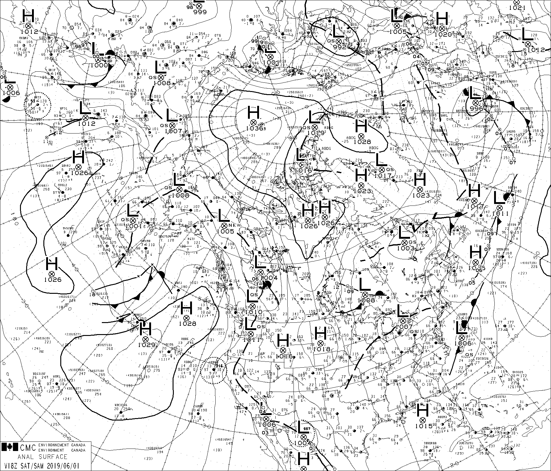
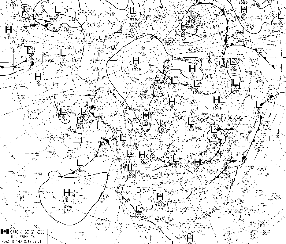
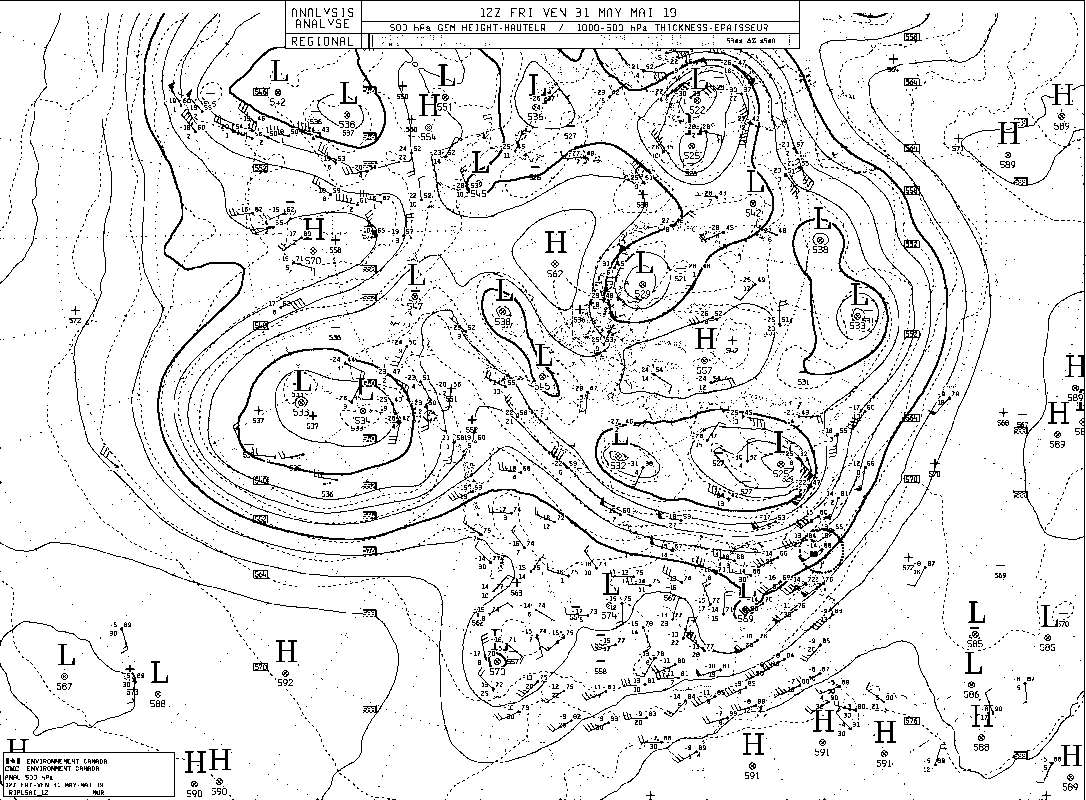
FORECASTER: Hilary Smith SYNOPTIC OVERVIEW: Low pressure located over the SPADE region, with a stationary front in BC and high pressure in Montana. There is also an upper level high pressure ridge.
Forecasters: Jeremy Morris SYNOPTIC OVERVIEW The low pressure system travelling along the BC-Yukon border is developing into a trough which will produce precipitation events throughout the province as it expands in the the next few days. In the short term, remnant high pressure still controls the weather in the SPADE region extending the dry spell of the weekend, with the possibility of more localized trace convective precipitation. GEM25 model output predicts continued dry conditions till Thursday when a mid latitude cyclone travelling from the Alaska may break inland through remaining high pressures in southeastern BC.
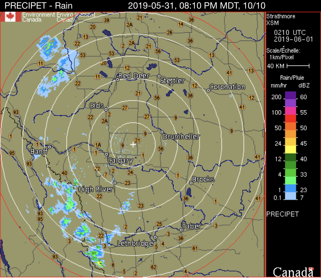
Forecasters: Jeremy Morris & Aurélie Desroches-Lapointe SYNOPTIC OVERVIEW The upper ridge continues to shift eastward allowing a low pressure system to move into BC, however this system is travelling along the BC-Yukon border and is not effecting weather in our study area. In the SPADE region, more of the same localized convective precipitation is expected by 21 UTC for roughly six hours as predicted by CMC-RDPS modelling. NAM modelling does not predict such convective precipitation events, although it does present a similar synoptic scenario.
 Forecasters : Cécile Carton & Selina Mitchell SYNOPTIC OVERVIEW There is an upper ridge moving from BC to Alberta today, while an upper-trough is moving into northwestern BC. Only convective precipitation is expected in southeastern BC today. There is a low over northwestern Alberta with a north-south orientation. Thunderstorms are expected to develop along the surface trough and ahead of the low. These thunderstorms are expected to be both isolated and non-severe, and storms in the southern part of the province are expected to dissipate this evening, due to a low moisture content in this region.
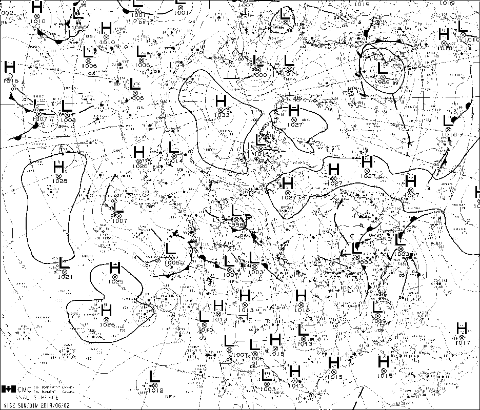
FORECASTER: Juris Almonte SYNOPTIC OVERVIEW: Much like the morning, the upper ridge at 500 hPa is still affecting western Canada, a low pressure system is situated off Alaska. Atmospheric river forecasts are showing IVT values over the 250 kg m-1 s-1 threshold by June 2nd and 3rd and then again on the 5th. Upper air charts are from 1200 UTC, as 0000 UTC charts were not available. Of interest next week, high amounts of precipitation are expected on the 5th according to the GEM 2.5. This may be associated with the long range atmospheric river forecast whereby, moisture is advected over to the Rockies from the Pacific.
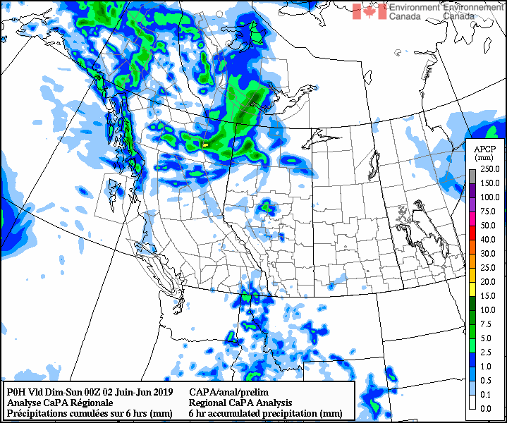
FORECASTER: Hilary Smith SYNOPTIC OVERVIEW: There is a high pressure system affecting the SPADE area and a developing trough to the west of the SPADE region from Yukon through BC into the US. There is currently nothing popping up on the radar for either of the field sites and we will be monitoring the radar throughout the day and nowcasting. Thunderstorms are possible at both sites.
FORECASTER: Selina Mitchell SYNOPTIC OVERVIEW: Widespread instability will give rise to showers with a risk of thunderstorms. Convection is expected mainly over ridge tops. Isolated showers are expected for the East Kootenays and the Elk Valley tomorrow morning. Also, afternoon convection is expected tomorrow in Alberta. There is a possibility of thunderstorms in southwestern Alberta. Overall, there is a greater risk of severe weather tomorrow, but the risk is still marginal. More instability is expected over the weekend throughout the study area.
|
ForecastersTeam of atmospheric scientists from across the nation. ArchivesCategories |

 RSS Feed
