GLOBAL WATER FUTURES
  • Updates
  • Blog
  • Photos
  • Forecast
  • Mission Statement
  • Participant Information
  • People Involved
  • Instruments
  • Contact us
  • Minutes

Forecast

Weather forecast – 14 UTC 10 June 2019

6/10/2019

0 Comments

 
Forecaster: Stephen Déry
​
Synoptic overview: The upper-level trough that affected the continental divide this past weekend has moved eastward into central Canada. In its place, an upper-level ridge is building across the western Cordillera bringing quiescent conditions for the early part of this week. Some mid- to upper level clouds will affect the continental divide in association with a warm front over the northeastern Pacific Ocean, which will diminish solar radiation and suppress air temperatures today. As well, some instability associated with cold air aloft may lead to showers and even the possibility of some thunderstorms, but these will be isolated. The building ridge will clear out skies starting Tuesday and suppress convection and precipitation until later in the week.
​Nipika
Partly cloudy conditions with a slight (40%) chance of showers today. Temperatures will remain on the mild side and likely reach 16°C by the afternoon with cooler temperatures during cloudy periods.  
Fortress Mountain
Partly cloudy conditions with also a slight (30%) chance of showers today at Fortress Mountain. Relatively mild conditions with a maximum near 10°C. Best chance for precipitation will be mid- to later afternoon as destabilization of near-surface air occurs.
Storm Mountain Lodge
Nearly identical conditions to Fortress with partly cloudy conditions and slight (30%) chance of showers today with a maximum near 10°C. Better chance for morning precipitation relative to the other sites

0 Comments

June 10th - 0100 UTC

6/9/2019

0 Comments

 
Forecaster : Cécile Carton

SYNOPTIC OVERVIEW
A ridge of high pressure is starting to build over the BC coast. While a series of frontal systems will take aim at the coast tomorrow, this ridge will ensure that they won't make it much further than the north coast of BC before weakening. As the ridge builds the temperature is expected to rise over the week.
NIPIKA
GEM 2.5 suggests no more than 1 mm of rain tomorrow between 3 AM and 7 AM MDT. Rest of the day clear. The temperature will be up to 15°C during the day and will remain above 5°C overnight. The CAPE will be very low.
The HRRR suggests no precipitation for tomorrow. The GEM Global suggests no precipitation until Thursday.

STORM MOUNTAIN LODGE
The GEM 2.5 and the HRRR suggest no precipitation for tomorrow. The temperature will be up to 5.5°C during the day and will remain above 0°C overnight. The CAPE will be very low.
The GEM Global suggests no precipitation until Thursday.
FORTRESS
GEM 2.5 suggests no more than 2 mm of rain tomorrow between 12PM and 2PM MDT. Rest of the day clear. The temperature will be up to 7.5°C during the day and will remain above 0°C overnight. The CAPE will be very low.
The HRRR suggests no precipitation for tomorrow. The GEM Global suggests no precipitation until Thursday.
0 Comments

9th of June - 1400 UTC

6/9/2019

0 Comments

 
Forecasters : Cécile Carton & Selina Mitchell

SYNOPTIC OVERVIEW
Off of the BC coast a ridge of high pressure is developing. Although frontal systems may try to move onto the the northwestern coast, they will not be able to progress very far within the next couple of days. With the exception of the northwestern coast, temperatures are expected to rise over much of BC., however today some unsettled conditions will persist and showers are possible though much of BC. There is a cool, unstable airmass above most of Alberta today, this will lead to unsettled conditions including scattered thunderstorms over a good portion of the province. Instability will vary greatly, but thunderstorms are expected to be most severe over the foothills.
NIPIKA
The GEM 2.5 suggests 3 mm of rain between 1 and 7 AM tomorrow, the rest of these 2 days should be clear from precipitation. Temperatures up to 15°C today and 13°C tomorrow.
The HRRR suggests no precipitation for these 2 days. The GEM Global suggests no precipitation until Thursday.

STORM MOUNTAIN LODGE
0.6 mm of rain and 0.5 cm of snow between 9 AM and 5 PM today, 0.3 mm of rain and 0.4 cm of snow between 10 AM and 1 PM tomorrow. Temperatures up to 7°C today and 5°C tomorrow. The CAPE remains under 1000.
The HRRR suggests no precipitation. The GEM Global suggests no precipitation until Friday.
FORTRESS
According to the GEM 2.5 0.4 mm of rain and 0.3 cm of snow are expected between 2 and 3 PM MDT today. The CAPE remains under 1000. Tomorrow 0.9 mm of rain and 0.5  between 11 AM and 3 PM. Temperatures up to 6°C for these days, above 0°C during the night. The CAPE is higher and might be above 1000 tomorrow, thunderstorms could happen.
The HRRR suggests no precipitation at all for these 2 days. The GEM Global suggests no precipitation at all until Friday.
0 Comments

May 09, 0130 UTC

6/8/2019

0 Comments

 
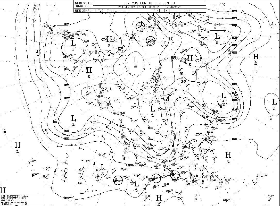
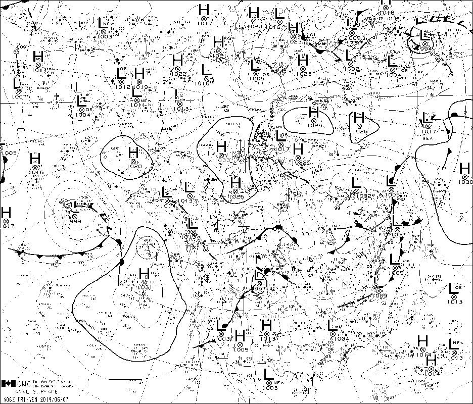
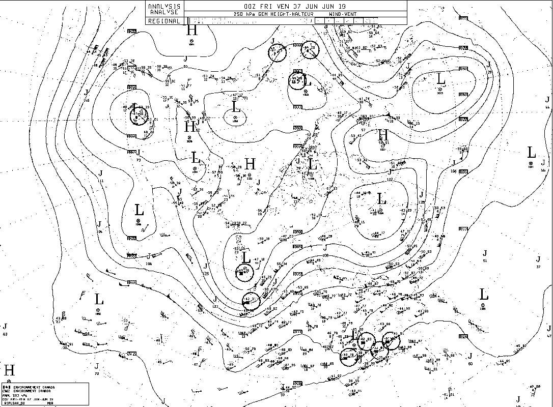
Forcasters: Aurélie Dseroches-Lapointe & Jeremy Morris
SYNOPTIC OVERVIEW:
Two surface low pressure systems are currently in vicinity of northwestern Canada, the first one being on the west shore of Hudson Bay, and the second over the Pacific Ocean off the coast of northen BC. A high pressure is also located south of the BC coast. No surface synoptic system is currently located in our area, so any precipitation occurring would be of orographic nature. This surface pattern seems to persist for the next few days, however higher levels patterns are moving across the continent.

Two troughs, at 500 hPa and  250hPa heights respectively, are currently over our study area, moving northeastwards and becoming more negatively tilted which correspond to the SE-NW direction. Additionally, high-level ridges (500 and 250 hPa respectively) are currently above the surface high pressure zone located over the Pacific Ocean  that was mentionned before. These ridges are building up as they approach us in the next few days.
NIPIKA: 
According to GEM25, a mixt of 0.9mm of rain and 0.4mm of snow is forecasted for tonight. Otherwise, significant precipitation is forecasted for Thurday afternoon into Friday just as for Fortress site.

GEM2.5 suggest rain for Monday early morning reaching a rate of 0.9 mm/h but GEM10  which has a more recent lasts simulation suggests only negligible amounts of precip. HRRR and Rap forecast no precipitation. NAM suggest traces amount for tomorrow early morning and two small showers of rain from 3pm to 5pm MDT.
FORTRESS:
None of the models suggest precip for at least nthe next three days. According to GEM25 no considerable amount of precip is expected until Thursday June 14th, when a important rain event is forecasted. This event should bring precip from Thursday, but mainly on Friday.
0 Comments

June 08 - 17UTC

6/8/2019

0 Comments

 
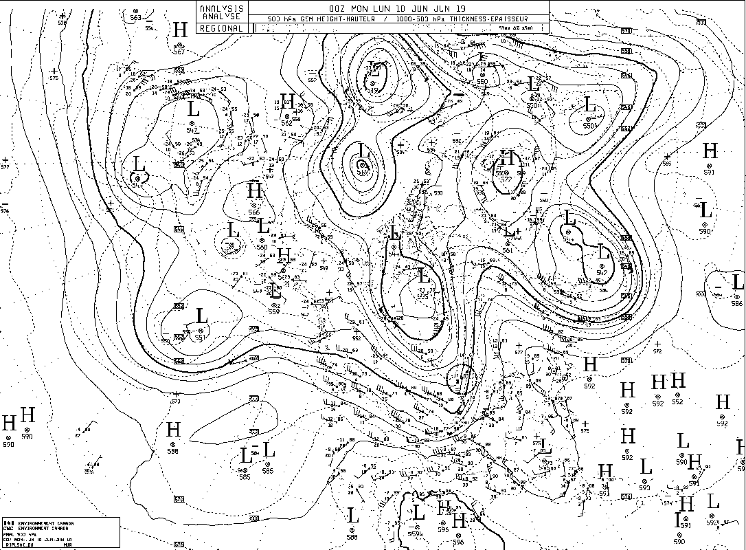
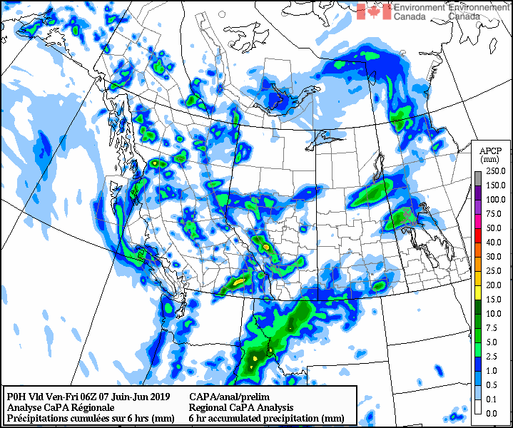
FORECASTER: Aurélie Desroches-Lapointe
SYNOPTIC OVERVIEW:
According to GEM10, GEM25 and NAM, a deep 500hPa trough is aligned S-N above our study area, with a  high pressure band over the rockies. Due to air flow coming from the NW, orographic showers and chances of storms are forecasted from now to Sunday 0600UTC. On a longer timescale, a low pressure system currently over the Pacific Ocean might start to affect our area on Monday around noon according to GEM10, and in the evening according to NAM (UTC). GEM2.5 suggests this system may barely reach our study zone. At higher elevations, 250hPa winds causing divergence, which could enhance any  potential precipitation, are forecasted from Monday evening onwards.
NIPIKA:
GEM2.5 spot forecast for NIPIKA agrees with its synoptics and forecasts spotty showers this afternoon (MDT). GEM 10 and GEM25, HRRR and RAP also suggest showers at slightly different times with slightly different amounts, but the main idea remains the same. Notice that RAP also suggests thunderstorms this evening from 1900 to 2100 MDT. NAM is the only model not suggesting any precip.
FORTRESS:
GEM25 suggest no precip until Thursday afternoon, and large amounts of rain, especially Friday. RAP and NAM suggest  convective snow today with thunderstorms  of negligible precip (less than trace) for Sunday. HRRR forecast small amounts of rain today while GEM10 suggest negligible amounts of snow due to spotty precipitations for today and tomorrow.
​
0 Comments

Weather Forecast 2100 UTC June 7, 2019

6/7/2019

0 Comments

 
Forecaster: Selina Mitchell

SYNOPTIC OVERVIEW: A cold upper trough is moving into south and central Alberta today and there is enhanced upslope precipitation in the Rockies as a consequence. A snowfall warning remains in effect for Banff and Kananaskis. Snow is expected to occur at 1400 m and above.
NIPIKA: Rain until 7 PM (0300 UTC) 3.5 mm accumulation, perhaps small amounts of snow (0.2 cm). Only small amounts of precipitation is expected on Saturday (possibly 4 mm of rain). There could be small amounts of snow tomorrow as well since, the ECCC  forecast has a chance of wet flurries in Kootenay National Park tomorrow. Lows of 1 C are expected overnight, but temperatures could rise as high as 11 C by noon tomorrow.
FORTRESS: This event will have upwards of 20 cm  snow accumulation, however it is expected to end by 11 PM (0500 UTC) tonight, or as late as 6 AM (1200 UTC) tomorrow morning according to some models. There may be temperatures below zero until 9 AM (1500 UTC) tomorrow morning. Only small amounts of snow are expected after midnight tonight if the storm persists.  Only trace amounts of rain or snow is expected tomorrow afternoon.

STORM LODGE: Temperatures are expected to remain slightly below freezing overnight, but only trace amounts of snow are expected overnight (possibly 0.5 cm accumulation).
0 Comments

Weather Forecast - 13:00 UTC 7 June 2019

6/7/2019

0 Comments

 
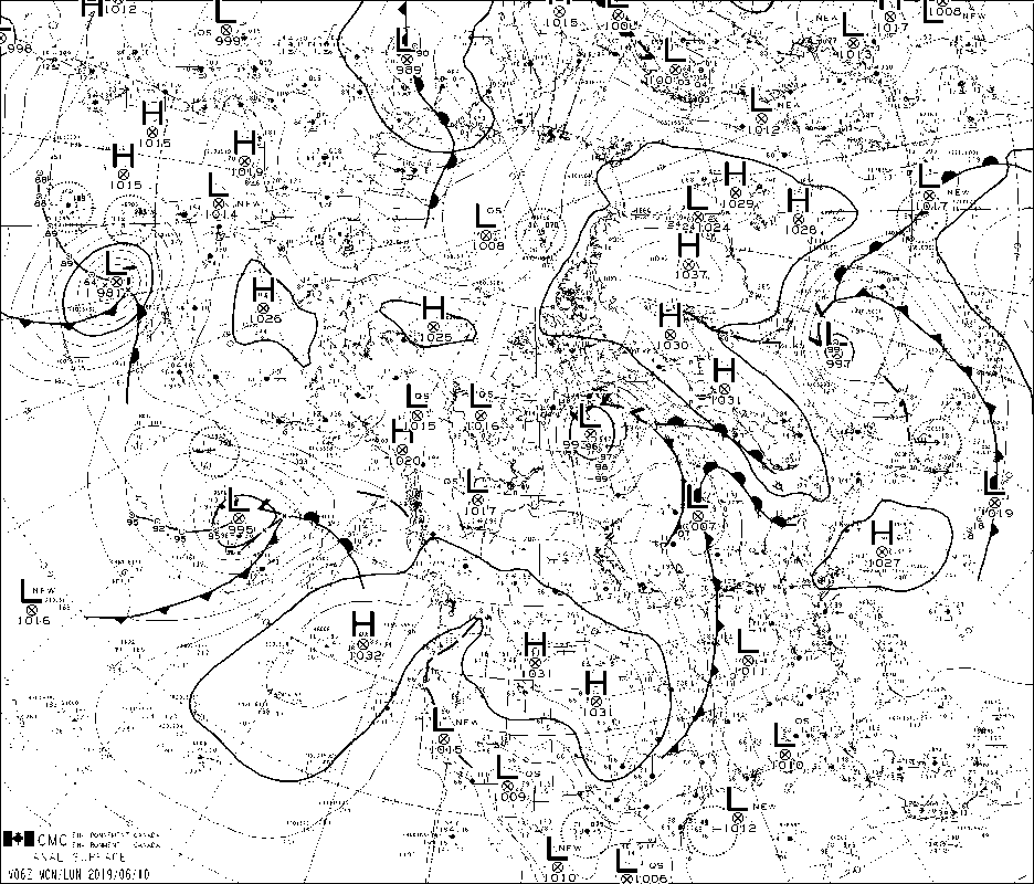
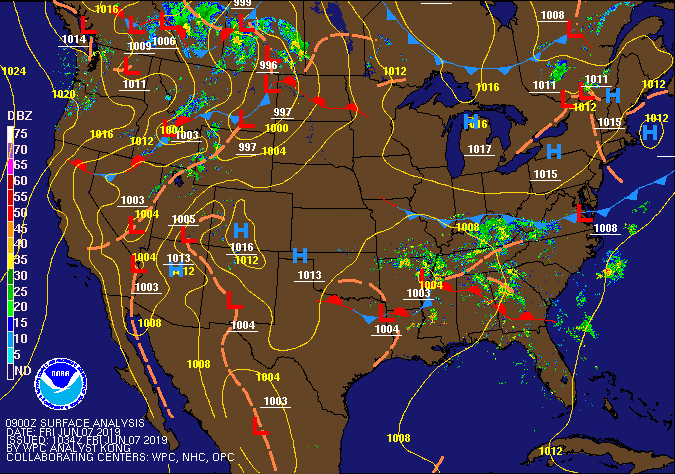
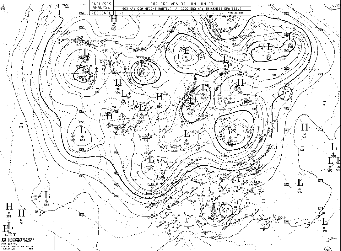
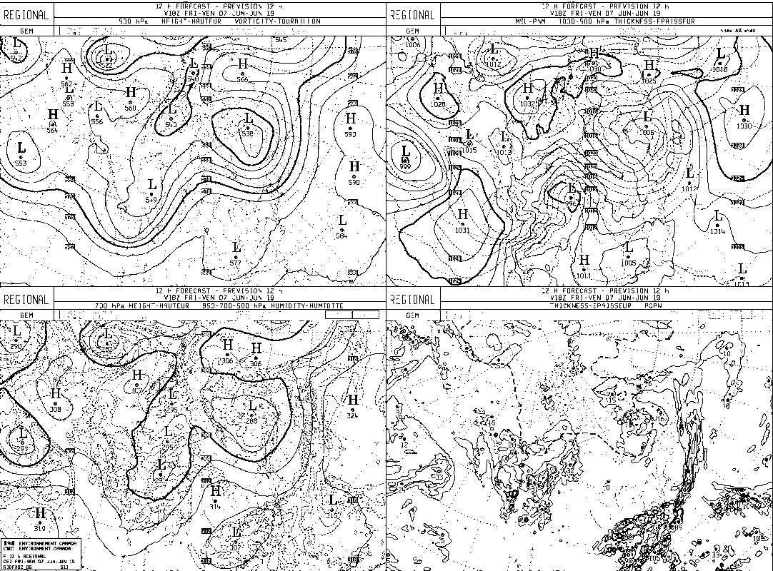
Forecaster: Stephen Déry & Angel

Synoptic overview: The continental divide is presently under the influence of a strong upper level trough currently moving across the western Cordillera with an associated surface low pressure system. The main surface low with central sea-level pressure of 997 hPa resides over Montana and will move northeastward into Saskatchewan this morning. Precipitation on the ‘back’ side of the system has impacted our study area overnight and the cloud and precipitation shields are moving back towards the southwest. Thus an upslope flow along the foothills of Alberta into the Rockies will develop. Temperatures are cool enough for snow at treeline and in the alpine, with the precipitation abating in the mid- to late afternoon. Gusty winds are likely today on the back side of the storm. Showery weather will follow on Saturday as we remain under the influence of the upper level trough as it moves eastward.
Nipika
Rain today with possible 5-10 mm of accumulation. Winds will be steady and gust up to 50 km/h. Temperatures will stay cool today but hover about the freezing mark so that precipitation will remain in the liquid form.
​Fortress Mountain
Conditions will remain cool at Fortress Mountain today and remain below the freezing mark today in periods of snow perhaps mixed with rain. Precipitation will continue throughout the day and diminish in intensity by mid-afternoon. Residual snow showers are likely thereafter and overnight as temperatures remain cool. Note that ECCC is continuing its snowfall warning for the region with highest snow accumulations likely in the norther sections of Banff National Park, with possibly up to 10 cm of snow.
Storm Mountain Lodge
Light to moderate snow will continue at Storm Mountain Lodge this morning where temperatures remain near freezing. Snow will continue until early afternoon before diminishing. Maximum today will reach about 0C.
0 Comments

June 6 - 1400 UTC

6/6/2019

0 Comments

 
Forecaster : Cécile Carton

SYNOPTIC OVERVIEW
A low pressure system associated to upper level lows over our area. The CAPE remains very low for the three sites.
NIPIKA
13.4 mm of rain expected between 7PM tonight and 9PM MDT tomorrow. Temperature dropping to 4°C tomorrow during the day.
According to the GEM global the temperature will drop to 0°C and we will have 6.6 cm of snow from Friday night to Saturday morning.
Precipitation should stop Saturday at 6AM MDT, with a clear weather for the 2 next days.

STORM LODGE
37 cm of snow expected between 4PM MDT today and 9PM MDT tomorrow (6.8 cm between 12PM and 1AM), temperature below 0°C tomorrow during the day. Another period of 12 cm of snow expected by the GEM global between Saturday 9PM and Sunday 12PM MDT.

FORTRESS
0.6 cm of snow, 1 mm of rain expected between 5PM and 7PM MDT today, 9.3 cm of snow between 7AM and 10PM MDT tomorrow.
The temperature will constantly drop until 2AM, time at which we will remain below 0°C for the whole day.
According to the GEM global we should expect another period of snow from Sunday 12 AM to 3PM MDT, with another 10 cm of snow.
0 Comments

June 6 - 0200 UTC

6/5/2019

0 Comments

 
FORECASTERS: Charlie Hébert-Pinard & Hilary Smith
SYNOPTIC OVERVIEW: Low pressure over the Pacific ocean is moving east towards the coast of BC. Several upper level lows over Canada, some of which support that surface low pressure and will allow some showers over the study area. However, only a small amount of rain is expected for the night and we should be affected more considerably starting tomorrow evening. Despite NAM indication, we should not expect any thunderstorms in the next 24h, with a very low CAPE for the three sites.
NIPIKA: GEM 2.5km indicates small amounts of rain for tonight (0.4mm) and tomorrow evening (1.1mm) with temperatures around 15 degrees. Things should get more interesting Friday with larger amounts of rain (and snow according to NAM, but I would not be too optimistic about it!)
FORTRESS: On Fortress side, according to GEM 2.5km, we expect 1.2mm of rain and maybe a trace of snow for tonight, with temperatures between 2 and 7 degrees. It should drop around zero for the next night allowing snow starting at 10pm MDT for a total amount of 3 cm. NAM agrees with those predictions with some small differences in the timing and the amount. 
STORM LODGE: Temperatures around 10 degrees in the day and 5 at night. We are expecting 2.6mm of rain for tonight and only a trace of precipitation for tomorrow evening.
0 Comments

June 5 - 1300 UTC

6/5/2019

0 Comments

 
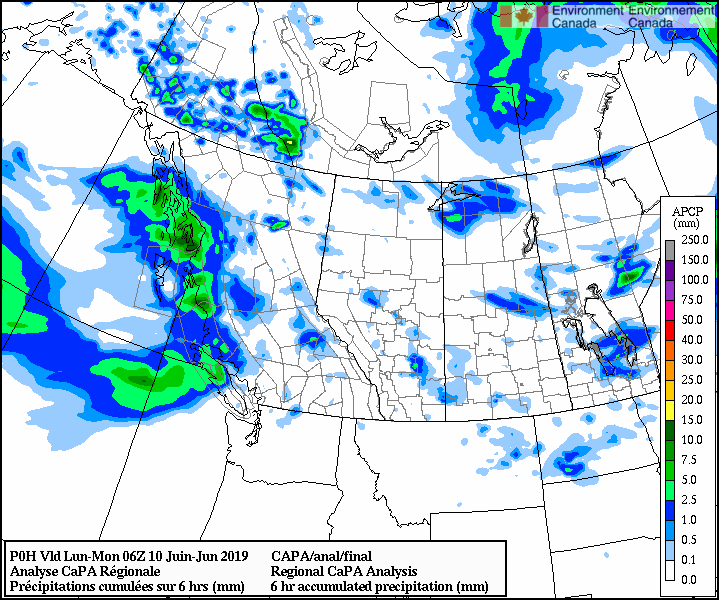
FORECASTER: Juris Almonte
SYNOPTIC OVERVIEW: A surface low over SE corner of NWT (1002 hPa) with a trough extending down into Montana.  24 h preliminary CaPA map is showing no precipitation till tomorrow morning.  Upper trough off the coast of BC and is moving eastward to make its way to the SPADE region by Thursday bringing wet conditions.
NIPIKA
GEM2.5 (1800 UTC) - Rain to begin at 1900 MDT , ending the early morning the following day at (June 6 - 0100 MDT) with 6.8 mm of rain expected. 

GEM25 (1800 UTC) - Largest event is to begin Friday morning and ending Saturday afternoon, with total amounts 5.8 mm of rain and 23.5 cm of snow. 

American models HRRR (1200 UTC), RAP (1300 UTC) - 
similar to GEM2.5, with rain beginning late evening.

NAM (0600 UTC) -  NAM showing rain to begin around 1500 MDT tomorrow with snow beginning around 0400 MDT (Friday) and ending midnight (MDT) on Saturday. A total of 5.5 mm of rain and 10.3 cm of snow is expected. 

FORTRESS
GEM2.5 (1800 UTC) - Forecast remains similar to yesterday  with precipitation beginning early evening (5 PM MDT), trickling into trace amounts by 1:00 MDT the following day (June 6). Total precipitation amounts are 4.5 mm of rain and 0.5 cm of snow.  Mostly rain is expected with temps around 3-4°C, however snow may also occur. 

NAM (0600 UTC) - Trace amounts of rain to begin Thursday morning, with higher intensity to begin Thursday evening 1800 MDT ending Saturday at midnight. 5.2 mm of rain and 23.1 cm of snow expected.

STORM LODGE 
GEM2.5 (1800 UTC) - Trace amounts of rain beginning at around 1500-1900 MDT and ending the following morning (June 6) at 0900 MDT. Temps will be near 5°C with SW flows.
​
BGI - GEM2.5 (1800 UTC) shows negligible amounts of precipitation expected today and tomorrow
0 Comments
<<Previous
Forward>>

    Forecasters

    Team of atmospheric scientists from across the nation.

    Archives

    June 2019
    May 2019
    April 2019

    Categories

    All

    RSS Feed

Powered by Create your own unique website with customizable templates.
  • Updates
  • Blog
  • Photos
  • Forecast
  • Mission Statement
  • Participant Information
  • People Involved
  • Instruments
  • Contact us
  • Minutes