GLOBAL WATER FUTURES
  • Updates
  • Blog
  • Photos
  • Forecast
  • Mission Statement
  • Participant Information
  • People Involved
  • Instruments
  • Contact us
  • Minutes

Forecast

June 17 - 0200 UTC

6/16/2019

0 Comments

 
FORECASTER: Hilary Smith

SYNOPTIC OVERVIEW
A high pressure system has moved out of the SPADE region into central AB. There is low pressure located at the borders of YK/NWT/BC with a trough going down into central Idaho. According to ECCC weather briefings, conditions will be unsettled tomorrow which could lead to showers or thunderstorms, which is reinforced by the upper low moving west across BC. An isolated severe storm that could bring 2-3 cm hail is predicted in the south-central foothills. 
NIPIKA
The GEM 2.5 km (1800 UTC) model run is showing 1.1 mm of liquid precipitation tomorrow between 2300 UTC June 17 and 0100 UTC June 18 with temperature highs in the mid-twenties. CAPE values will be mostly <1000 J/kg, with very light winds predominantly from the south and west. The HRRR (2300 UTC) model run is showing no precipitation tomorrow morning, and the RAP (2300 UTC) is showing only trace precipitation early tomorrow morning. The NAM (1800 UTC) model run is showing trace precipitation tomorrow morning. All models are showing CAPE values <1000 J/kg. The GEM 25 km (1200 UTC) model run is showing 0.3 mm of liquid precipitation from 1800 UTC to 2100 UTC tomorrow. The long term forecast suggests that substantial precipitation will begin at 1200 UTC June 18 and continue for a few days, with the possibility of solid precipitation on Thursday afternoon and overnight.

STORM LODGE
​The GEM 2.5 km (1800 UTC) model run is showing 9.4 mm  of liquid precipitation tomorrow from 1800 UTC to 2000 UTC and 0.5 mm from 0200 UTC to 0300 UTC June 18 with temperature highs in the high-teens. CAPE values will be >1500 J/kg tomorrow afternoon, with light variable winds. The high CAPE values coincide with the high amounts of precipitation so it is likely that this could be due to a thunderstorm tomorrow afternoon. The HRRR (0000 UTC June 17) is showing no precipitation tomorrow, and the RAP (2300 UTC) model run is showing trace precipitation  late tomorrow morning. The NAM (1800 UTC) model run is showing trace precipitation tomorrow throughout the day. CAPE values are <1000 J/kg in all models. The GEM 25 km (1200 UTC) model run is showing 0.4 mm of liquid precipitation from 1200 UTC to 1500 UTC Tuesday. The long term forecast suggests that substantial precipitation will begin at 0600 UTC June 19 and continue for a few days, with the possibility of solid precipitation on Wednesday afternoon.
FORTRESS
The GEM 2.5 km (1800 UTC) model run is showing 3.1 mm of liquid precipitation tomorrow, with the majority occurring from 1700 UTC June 17 to 0200 UTC June 18. Temperature highs are expected to be in the mid-teens. CAPE values will reach ~1000 J/kg but will be < 1000 J/kg for the majority of the day, with predominantly light SSW winds. The HRRR (2300 UTC) model run is showing no precipitation tomorrow morning, and the RAP (2300 UTC) is showing only trace trace precipitation tomorrow morning and early afternoon. The NAM (1800 UTC) model run is showing 4.7 mm of liquid precipitation tomorrow afternoon and early evening with the possibility of thunderstorms. All models are showing CAPE values <1000 J/kg. The GEM 25 km (1200 UTC) model run is showing 0.5 mm of liquid precipitation from 1800 UTC to 2100 UTC tomorrow. The long term forecast suggests that substantial precipitation will begin at 1800 UTC June 18 and continue for a few days, with the possibility of solid precipitation on Thursday afternoon.
0 Comments

June 16 - 1500 UTC

6/16/2019

0 Comments

 
FORECASTER: Selina Mitchell 
SYNOPTIC OVERVIEW: A surface high is located on the coast off BC. A low pressure system is forecasted to move along the foothills of the mountains and by Tuesday is forecasted to be to the east of the SPADE region. By Wednesday as the low tracks further south, we expect more upslope precipitation along the foothills of the Rockies, bringing precipitation to the eastern side of our region. GEM global shows the low deepening throughout the week.  
NIPIKA
Highs of around 25°C both today and tomorrow. Negligible precipitation starting at 3 PM tomorrow afternoon and occurring intermittently throughout the evening. Next large precipitation event is supposed to occur on Wednesday. Another large precipitation precipitation event is expected on Friday. Snow is a possibility on Friday, but it is unlikely since the model run  is at a higher elevation than Nipika.
​
FORTRESS MOUNTAIN
Highs of 16°C are expected today and tomorrow. Small amounts of rain is expected starting around 3 PM today. There could be upwards of 1.9 mm. Large amounts of precipitation are expected at around noon tomorrow. This could be somewhere between 15 and 25 mm according to the GEM 2.5. However, lower resolution models have only negligible amounts of precipitation for tomorrow at Fortress. Eight millimetres of rain is expected on Wednesday and snow is a possibility on Friday morning.
STORM LODGE
Midnight run of GEM 2.5 predicts highs of 19 C today and tomorrow, with negligible rain starting at 6 PM this evening. Three millimetres of rain is expected between noon and 5 PM tomorrow. Other GEM models predict similar precipitation patterns of slightly different amounts, but no large precipitation events are expected either today or tomorrow. GEM global from 6 PM yesterday suggests snow Wednesday afternoon and snow Thursday evening. This is supported by another model.
0 Comments

June 16th - 0100 UTC

6/15/2019

0 Comments

 
Forecaster : Cécile Carton

SYNOPTIC OVERVIEW
An upper trough and an associated cold front begin to move towards BC, and will probably bring showers and thunderstorms in BC for Sunday afternoon. These conditions will supposedly continue into Monday and Tuesday. Stabilized conditions are expected in Alberta tomorrow as the upper ridge of high pressure which was located in BC today is moving eastwards.
NIPIKA
The GEM10 doesn't expect any precipitation for tomorrow. Temperature up to 23°C, a CAPE under 1000.
The HRRR, the RAP and the NAM don't expect any precipitation for tomorrow.
The GEM25 (run from 6AM MDT) expects 1.2 mm of rain on Tuesday, 7.8 mm of rain Wednesday between 6AM and 9PM MDT.


STORM MOUNTAIN LODGE
The GEM10 expects 0.6 mm of rain tomorrow between 4PM and 8PM MDT. Temperature up to 15°C, a CAPE under 1000.
The HRRR and the RAP don't expect any precipitation for tomorrow. The NAM expects showers between 5AM and 8AM UTC.
The GEM25 (run from 6AM MDT) expects 16.8 mm of rain, 7.4 cm of snow between Wednesday 3AM and Thursday 00 AM MDT.
FORTRESS
The GEM10 expects showers tomorrow afternoon, 1.1 mm of rain between 3PM and 6PM MDT. Temperature up to 13°C, a CAPE under 1000. The HRRR and the RAP don't expect any precipitation for tomorrow. The NAM expects showers between 5PM and 10PM MDT.
The GEM25 (run from 6AM MDT) expects 29.4 mm of rain between Tuesday 9AM and Thursday 00AM MDT.

0 Comments

June 15 - 0100 UTC

6/14/2019

0 Comments

 
 FORECASTER: Hilary Smith

SYNOPTIC OVERVIEW
There is currently high pressure located over the Rockies. The low pressure that was affecting the area has moved eastward to the border of AB and SK. According to ECCC weather briefings, a high pressure ridge is building on the BC coast which will bring clear and dry conditions to the interior of BC tomorrow and move eastward towards AB over the course of the day. 
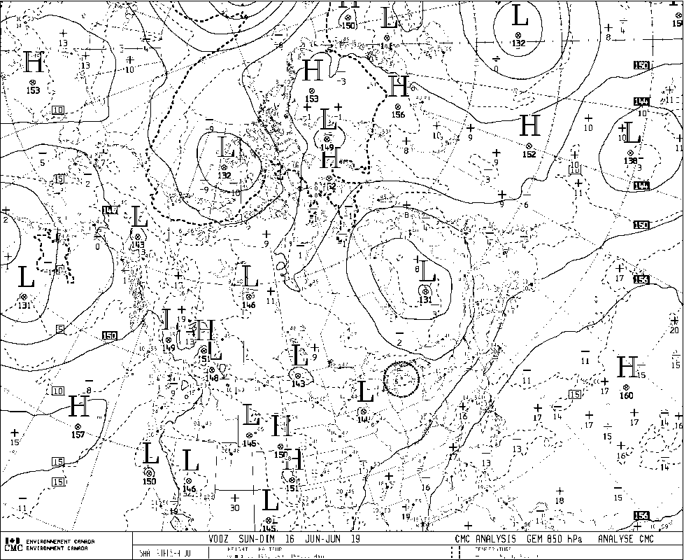
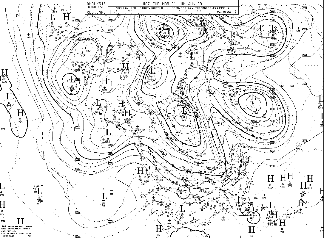
NIPIKA
The GEM 2.5 km (1800 UTC) model run is showing no precipitation tomorrow with temperature highs in the low-twenties. CAPE values will be well below 1000 J/kg, with light northerly winds becoming northwesterly in the afternoon. The HRRR (2300 UTC), the RAP (2300 UTC), and the NAM (1800 UTC) model runs are all showing no precipitation tomorrow with CAPE values near 0 J/kg. The GEM 25 km (1200 UTC) model run is showing liquid precipitation for a few days starting on Monday, with the possibility of solid precipitation on Thursday.

STORM LODGE
The GEM 2.5 km (1800 UTC) model run is showing no precipitation tomorrow with temperature highs in the high-teens. CAPE values will be well below 1000 J/kg, with light northerly winds becoming easterly in the evening. The HRRR (2300 UTC), the RAP (2300 UTC), and the NAM (1800 UTC) model runs are all showing no precipitation tomorrow with CAPE values near 0 J/kg. The GEM 25 km (1200 UTC) model run is showing liquid precipitation starting Sunday evening and continuing for a few days, with the possibility of solid precipitation starting on Wednesday afternoon. 
FORTRESS
​The GEM 2.5 km (1800 UTC) model run 
is showing trace precipitation tomorrow afternoon with temperature highs in the low-teens. CAPE values will be well below 1000 J/kg, with light northeasterly winds. The HRRR (2300 UTC) model run is showing no precipitation, whereas the RAP (2300 UTC) model is showing trace precipitation overnight, and the NAM (1800 UTC) model run is showing 1 mm of precipitation overnight and 3.8 mm from 2300 UTC June 15 to 0500 UTC June 16. All models are showing CAPE values near 0 J/kg. The GEM 25 km (1200 UTC) model run is showing small amounts liquid precipitation Sunday and Monday afternoons, and larger amounts starting on Tuesday and continuing for a few days, with the possibility of solid precipitation starting on Thursday morning. 
0 Comments

June 14 - 1400 UTC

6/14/2019

0 Comments

 
 FORECASTER : Aurélie Desroches-Lapointe

SYNOPTIC OVERVIEW:
​
The cyclonic circulation around a surface low pressure system surported by a 500hPa trought is currently located over the Northern border between Alberta and Manitoba. The associate driven northwesterly flow may bring precipitation over our study area. Due to the orogrpahy and the warm expected temperatures, intermittent rain episodes are forecasted for today for the eastern side of the divide.

A major low pressure system is currently in the Pacific Ocean. There is currently a ridge between our study area and this system, specifically on the west coast of British Columbia. The long-term models suggest an eastward shift of this synoptic pattern, causing our study area to be affected by this depression over the next week.  A follow-up of the short-term models will make it possible to bring more precision on the precipitation events that are expected, considering that snow could occure.
NIPIKA:
​
No precip are expected for today and tomorrow from the 12AM run of GEM2.5, the 6PM run of GEM25,  the HRRR (8AM run) and the NAM (6AM run)
GEM10 and RAP forecast negligible amounts of precip occuting this evening and no precip for tomorrow.


​
STROMLODGE:

None or small amounts of precipitation suggested for this week-end at Storm Mountain  Lodge. Moreover, this site, just like Fortress and NMipika is likely to be affected by the important low pressure system during the following week.
​
FORTRESS:

Morning runs of GEM10, NAM and RAP forecast a rain event for today:
GEM10 suggests rain between 10h00 and 19h00 MDT reaching a maximal precipitation rate of 1.1 mm/h and totalizing 11 mm. 
RAP forecasted rain occuring between 13h00 and 23h00 MDT with most of the precip (4.4 mm) between 14h00 and 17h00. This model also suggests a total amount of rain of 6.8 mm for the whole event and trace amounts from 20h00 until 23h00 MDT. 
​NAM suggests continuous rain today until 22h00 MDT totalizing over 8 mm and with thunderstorm between 09h00 to 14h00 and 16h00 to 21h00 MDT.

HRRR (8AM run) forecasts a rain shower between 14h00 and 15h00 MDT and a smaller rain episode of 1 mm from 16h00 until 17h00 MDT. GEM2.5 (12AM run) suggests intermittent trace amounts of rain occuring between 06h00 and 22h00 MDT resulting in a total amount of 1 mm of rain.
0 Comments

June 14 - 0130 UTC

6/13/2019

0 Comments

 
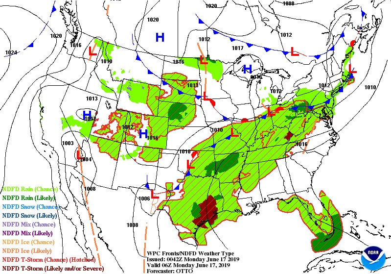
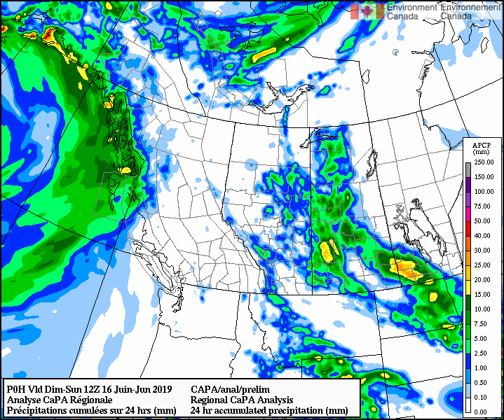
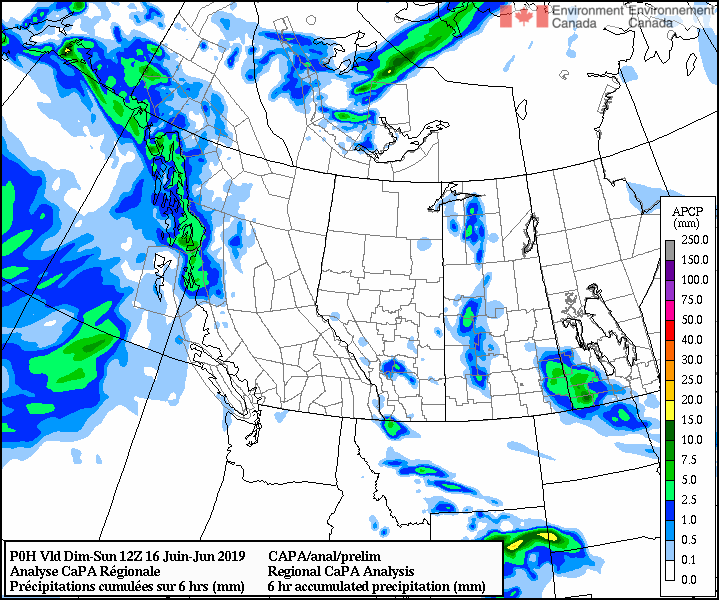
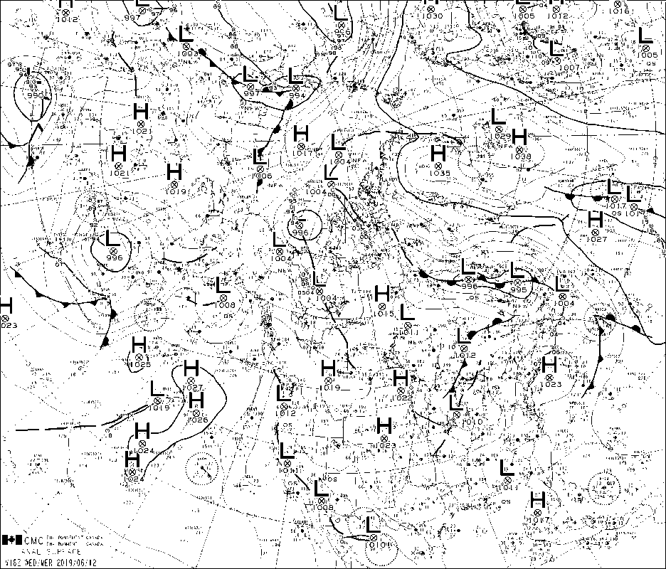
FORECASTER: Hilary Smith

SYNOPTIC OVERVIEW
There is a low pressure system located over the BC interior and moving into Alberta, as well as a cold front moving into the SPADE region from the NW. According to ECCC weather briefings, there will be unsettled conditions after the passage of the cold front through the region. With the cold front moving in AB, there is a chance for thunderstorms tomorrow afternoon. There is also still a chance of thunderstorms in the BC interior. 
NIPIKA
The GEM 2.5 km (1800 UTC) model run is showing 2.2 mm of liquid precipitation between 1000 UTC and 1200 UTC tomorrow morning with temperature highs in the low-twenties. CAPE values will be <1000 J/kg, with northwesterly winds. The HRRR (2300 UTC) model run is showing 1.6 mm of liquid precipitation between 0800 UTC and 1000 UTC and the RAP (2300 UTC) model run is showing 0.4 mm of liquid precipitation at 0500 UTC. CAPE values are <1000 J/kg in both models. The GEM 25 km (1200 UTC) model run is showing trace amounts of precipitation tomorrow afternoon.

STORM LODGE
The GEM 2.5 km (1800 UTC) model run is showing 1.6 mm of liquid precipitation between 0800 UTC and 1000 UTC tomorrow morning and trace amounts of liquid precipitation in the afternoon with temperature highs in the mid-teens. CAPE values will be <1000 J/kg, with northwesterly winds. The HRRR (2300 UTC) model run is showing no precipitation tomorrow and the RAP (2300 UTC) model run is showing 0.8 mm of liquid precipitation at 0500 UTC. CAPE values are <1000 J/kg in both models. 
The GEM 25 km (1200 UTC) model run is showing 8.8 mm of precipitation throughout the day tomorrow ending at 2100 UTC. 
FORTRESS
The GEM 2.5 km (1800 UTC) model run is showing 7.9 mm of liquid precipitation between 1000 UTC June 14 and 0000 UTC June 15, with a small break between 1200 UTC and 1500 UTC, and temperature highs in the low-teens. CAPE values will be <1000 J/kg, with predominantly northerly winds. The HRRR (2300 UTC) model run is showing 1.2 mm of liquid precipitation between 0800 UTC and 1100 UTC and the RAP (2300 UTC) model run is showing 1.9 mm of liquid precipitation at 0o00 UTC June 14 to 0700 UTC. CAPE values are near zero in both models. The GEM 25 km (1200 UTC) model run is showing 8.2 mm of liquid precipitation until 0000 UTC June 15.
0 Comments

June 13 - 1300UTC

6/13/2019

0 Comments

 
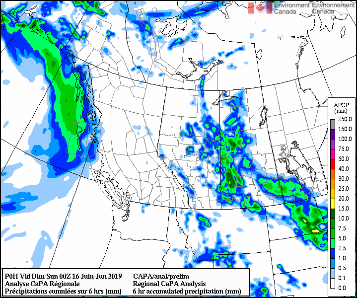
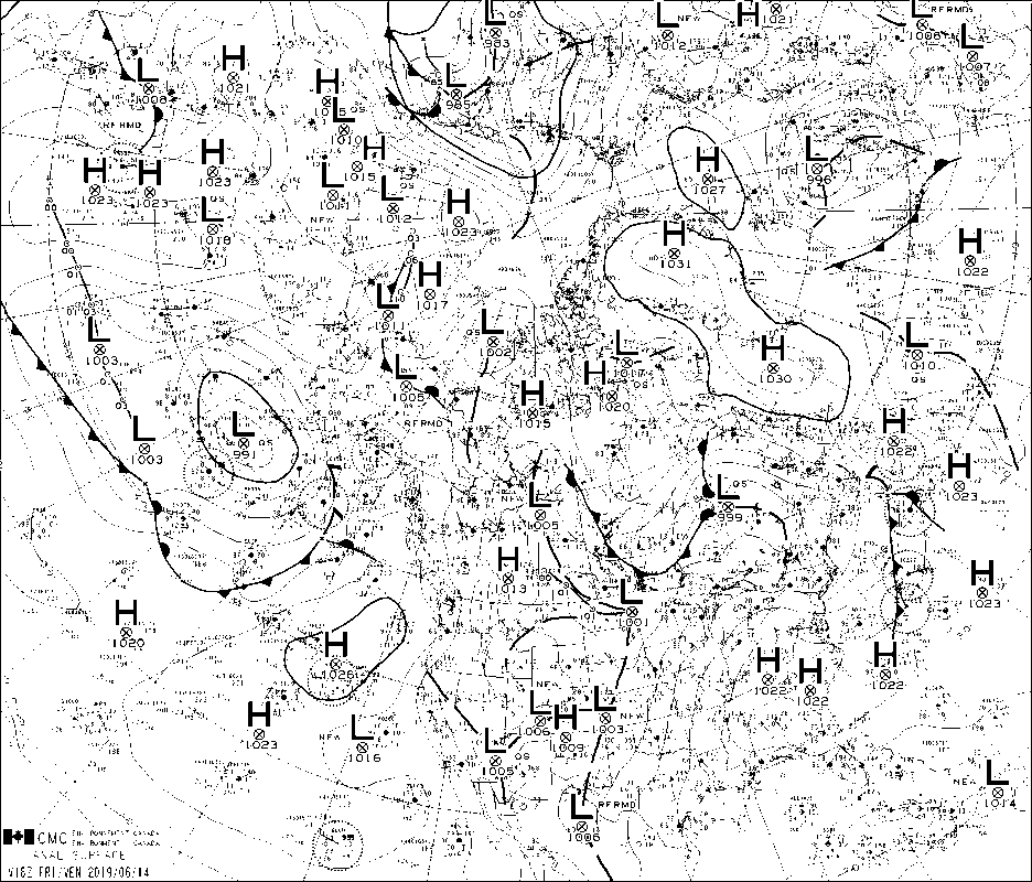
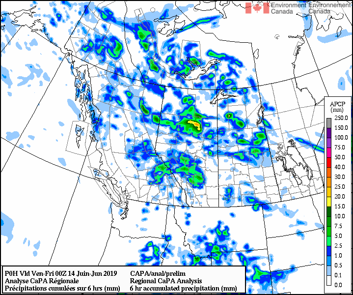
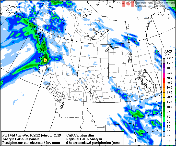
FORECASTER: Jeremy Morris
SYNOPTIC OVERVIEW
The cold front is making its way across the province today, sweeping its way southeastwards across the southern interior causing cold temperatures and isolated showers with a risk of wind gusts and small hail. Wet conditions may continue through tomorrow while instability remains. Within the SPADE region, this translates to predictions of regional precipitation, however the available high resolution models (GEM2.5 and HRR) do not predict significant rain, suggesting that possible events will be site specific as a function of the convective nature of cold front precipitation.
NIPIKA
GEM25 (0000 UTC) - 1.4mm of rainfall are expected to occur between 3pm and 6pm MDT today, with another 0.4mm expected  at 3am MDT Friday.  The next precipitation is forecasted for Wednesday afternoon, bringing 8.5mm of rainfall to the site.

GEM10 (0600 UTC) - Spotty rainfall forecasted at 1pm, 9pm, and 5am MDT amounting to 0.7mm, 0.3mm, and 2.6mm respectively. 

GEM2.5 (0000 UTC) - Simlar to GEM10, low levels of rainfall predicted for 1pm, 8pm MDT with amounts of 0.3mm, 0.1mm respectively. 5mm is predicted to occur between 2am and 5am MDT.

HRRR (1200 UTC) - 0.8mm rainfall predicted for 1pm today, coinciding with a slight drop in temperatures.

RAP  (1200 UTC)  - light rainfall event with chance of thunder in the forecast to start at 11 am MDT with a total amount of 4mm by end of Thursday
FORTRESS
GEM25 (0000 UTC) - 0.3 mm rainfall expected today at 3pm MDT, with another 2.5mm rain between 3am MDT and 3pm MDT Friday.

GEM10 (0600 UTC) - Trace rain for today with a significant 17mm forecasted to occur between 1am and 4pm MDT Friday, the bulk of which expected to fall between 5am and 8am MDT.

GEM2.5 (0000 UTC) - 3.5mm rainfall to occur at 9pm MDT tonight and light rainfall forecasted for early Friday morning amounting to 1mm.

HRRR (1200 UTC) - 0.4mm rainfall predicted for 6pm MDT today.

RAP (1200 UTC) - Intermittent light rain with risk of thunder predicted to start at 11 and continue to midnight, amounting to 5.5mm total.
​STORM LODGE
GEM25 (0000 UTC) - 4.3mm between 9pm and midnight today, Some excitement is forecasted for Monday into Tuesday with dropping temperatures, and potential for 40mm of rain with slight chance of mixed precip.

GEM10 (0600 UTC)- 3.5mm rainfall to occur at 11pm MDT, with more significant rainfall (up to 15mm) to occur between 3am and 6pm MDT.

GEM2.5 (0000 UTC) - No precip forecasted through to Friday evening.

HRRR (1300 UTC) - Trace today.

RAP (1300 UTC) - Rain with chance of the thunder to occur between 10am and 8pm, amounting to 12mm
0 Comments

June 13 - 0200 UTC

6/12/2019

0 Comments

 
FORECASTER: Hilary Smith

SYNOPTIC OVERVIEW
There is currently a high pressure system located directly over the Rockies. Tomorrow a cold front will be moving across the BC interior and into western Alberta, which will bring cooler temperatures and the possibility of severe thunderstorms on both sides of the continental divide. According to ECCC weather briefings, the high pressure ridge will likely rebuild in BC on Friday. 
NIPIKA
The GEM 2.5 km (1800 UTC) model run is showing trace precipitation tomorrow afternoon with temperatures in the mid-twenties. CAPE values will be >1000 J/kg around noon and in the afternoon, with winds increasing  and becoming westerly. The HRRR (2300 UTC) and the RAP (2300 UTC) model runs are also showing trace or small amounts of precipitation in the afternoon with CAPE values ~1000 J/kg and the possibility of severe thunderstorms. The GEM 25 km (1200 UTC) model run is showing trace amounts of precipitation tomorrow afternoon and  Friday morning. 

STORM LODGE
The GEM 2.5 km (1800 UTC) model run is showing small amounts of liquid precipitation tomorrow afternoon (0.8 mm) with temperatures in the low-twenties. CAPE values will be >1000 J/kg around noon, with winds becoming moderate  and westerly. The HRRR (2300 UTC) and the RAP (2300 UTC) model runs are showing
 no precipitation in the afternoon with CAPE values >1000 J/kg and the possibility of severe thunderstorms. The GEM 25 km (1200 UTC) model run is showing trace amounts of precipitation tomorrow evening and into  Friday morning. 
FORTRESS
The GEM 2.5 km (1800 UTC) model run is showing no precipitation tomorrow afternoon with temperatures in the high teens. CAPE values will be >1000 J/kg throughout the day, with winds becoming moderate and westerly. The HRRR (2300 UTC) and the RAP (2300 UTC) model runs are also showing no precipitation or trace amounts of precipitation in the afternoon with CAPE values ~1000 J/kg and the possibility of severe thunderstorms. The GEM 25 km (1200 UTC) model run is showing precipitation starting tomorrow evening and continuing into Friday morning. 

0 Comments

June 12th - 1400 UTC

6/12/2019

0 Comments

 
Forecaster : Cécile Carton

SYNOPTIC OVERVIEW
A cold front will begin to sweep south across the BC interior today, provoking showers and risk of thunderstorms. These showers and thunderstorms will persist through the night and spread eastward. On Thursday, as the front continues to move across BC, the atmosphere will be destabilized. Temperatures will be several degrees cooler. Showers and thunderstorms over BC interior will spread to the southern interior of BC on Thursday afternoon. But by Friday this feature will already be moving into Alberta, leaving a ridge of high pressure to rebuild over BC. This will mean clearing from west to east through the day.

NIPIKA
According to GEM-LAM no more than 0.2 mm of rain expected between 11 AM and 12 PM UTC today, the rest of today and tomorrow remain clear. Temperature up to 25°C today, 26°C tomorrow, above 12°C during the night. The CAPE remains under 1000. The HRRR suggests no precipitation today and tomorrow. According to GEM-GLB, 1.5 mm of rain to be expected on Thursday between 12 PM and 6 PM UTC, some showers on Friday.

STORM MOUNTAIN LODGE
According to GEM-LAM 11.6 mm of rain expected between 10 AM and 8 PM tomorrow. Temperature up to 18°C today, 15°C tomorrow, above 6°C during the night. The CAPE remains under 1000. The HRRR suggests no precipitation for today and tomorrow. According to GEM-GLB, 4 mm of rain to be expected between Thursday 9 PM and Friday 12 PM, with a peak of 3.1 mm on Friday between 12 AM and 3 AM.
FORTRESS
According to GEM-LAM no more than 0.4 mm of rain expected between 8 PM and 9 PM UTC today, the rest of today and tomorrow remain clear. Temperature up to 19°C today, 18°C tomorrow, above 7°C during the night. The CAPE remains under 1000. The HRRR suggests 0.2 mm of rain between 6 and 8 PM today. According to GEM-GLB, 6.5 mm of rain to be expected between Thursday 3 PM UTC and Friday 3 PM UTC, with a peak of 3.9 mm on Friday between 12 AM and 6 AM UTC.
0 Comments

June 11, 2019 - 1300 UTC

6/11/2019

0 Comments

 
FORECASTER(S): Selina Mitchell & Juris Almonte
SYNOPTIC OVERVIEW: Much like yesterday's forecast, upper level ridging (700 and upwards) is building over BC, bringing a north westerly flow over the SPADE region, therefore some cooler temperatures aloft.  Convective cells may pop up, but is more likely to the north of our region.  Satellite imagery shows cloud cover over our area. Tomorrow should bring warmer temperatures. 
NIPIKA: No precipitation is expected either today or tomorrow with highs of 20°C and 22°C respectively. Rain may commence around noon on Thursday with a total accumulation of 2 mm. No precipitation is expected on Friday. No snow is expected.
FORTRESS: A high of upwards of 13°C is expected today and 19°C is expected tomorrow. Precipitation is expected to start around noon on Thursday when temperatures are around 18°C. Precipitation is expected both Thursday and Friday with an accumulation of 7 mm. No snow is expected.

STORM LODGE: ​A high of 14°C is expected today and tomorrow, with a likelihood of higher temperatures. Precipitation is expected to start at 9 AM on Thursday, with heavy precipitation starting around noon. Precipitation is also expected Friday, and a total accumulation of 4.6 mm of rain is expected for both days. No snow is expected.
0 Comments
<<Previous
Forward>>

    Forecasters

    Team of atmospheric scientists from across the nation.

    Archives

    June 2019
    May 2019
    April 2019

    Categories

    All

    RSS Feed

Powered by Create your own unique website with customizable templates.
  • Updates
  • Blog
  • Photos
  • Forecast
  • Mission Statement
  • Participant Information
  • People Involved
  • Instruments
  • Contact us
  • Minutes