Nipika Fortress
0 Comments
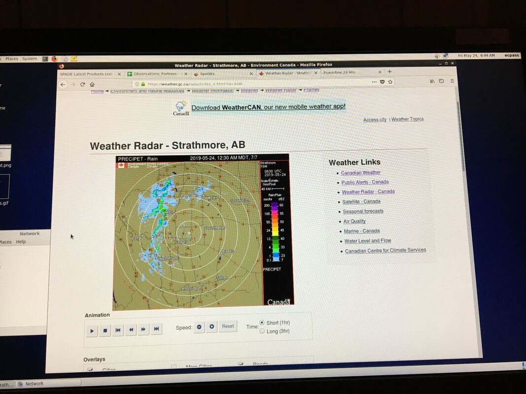
A beautiful day to download data and check the precipitation gauges Selina, Juris, and I (Hilary) went to visit the Nipika site to make sure that all instruments were functioning properly and to complete a data download. Everything was working properly and once the data download was complete, we left to check on Selina's FLNRORD precipitation gauge transect and to download more data. After a beautiful drive to precipitation gauge 1, we were delighted to find that it was still standing upright and recording data, albeit with a few loose screws. After downloading the data and securing the screws into the platform, we taped around the platform to ensure that we wouldn't lose any screws should they become loose again. We also made sure that the platform was level and that the guy lines were tight. We have a strong suspicion that the issues with this gauge are due to the strong katabatic winds and that this will likely be a continuing problem. It was my first time driving that far up the road and visiting the gauge, and wow - such beautiful scenery! The views are incredible and the roar of the two waterfalls in the background was very peaceful. I will volunteer to visit that rain gauge any day! Check out the youtube video we made of Selina explaining her gauge https://www.youtube.com/watch?v=ABMWQYUJ3Qs (see if you can spot the special cameo at the end...). We then drove to gauges 2 and 3 where we downloaded the data and encountered no issues. We returned back to Radium Hot Springs around 5pm after a very successful day. -Hilary Field Participants: Selina Mitchell, Juris Almonte & Hilary Smith The SPADE team had been highly anticipating this snow storm for a full week, as the models were all suggesting plenty of snow (~20 to 40 cm of snow) and on both sides of the Continental Divide. This was viewed as an opportunity for our team to deploy the MRR pro along with a few other instruments at Storm Lodge, with field participants taking observations and snow crystal photos on site. Snowfall warnings in Kananaskis, Bow Valley and Banff were issued by ECCC.
Nipika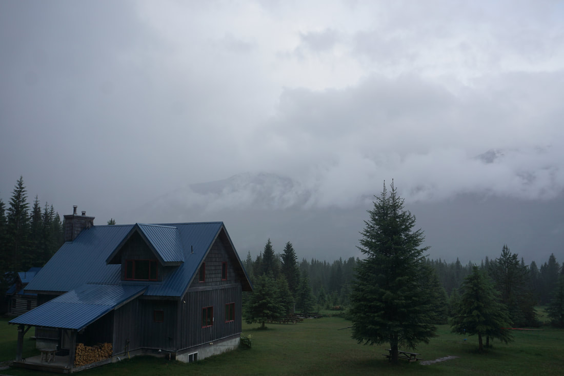 View of a sleepy and damp Nipika Resort at 0600MDT on June 7 Storm LodgeFortressChecking up on the precipitation gauges Nothing was expected over the SPADE region, so Jeremy and I took advantage of the quiet Sunday to collect the data from the tipping bucket rain gauges (provided by FLNRORD) and to check up on Nipika. Neither of us had been down the transect previously, but with a handheld GPS and guidance provided by Selina and Stephen, we were able to find all three sites. Unfortunately, precipitation gauge 1, the closest site to the continental divide and Fortress Mountain was found dangling on its cord (see pictures below). Thankfully, no damage was done to the unit, but we suspect that high winds were the issue, given the exposure to katabatic winds from the mountains. Jeremy had also noticed that the guy wires were loose, adding to our suspicion of high winds. Moreover, no signs of a bear were found close to the site. We downloaded the data, which showed several tips on the 24th and 25th. Jeremy took a look at the data and suspects the gauge came down on the 25th. We made sure to test the gauge prior to our departure. After an excessive amount of manual tips, we decided it was still functioning properly. The gauge platform was reinforced with a second bracket and levelled. No snow was observed in the area, in the creek nearby, or in the narrow avalanche chute. Across the creek, however, we did see some remnant snow in the shade. The remaining two sites were both in great condition. Again, no signs of bears and all data were downloaded. Both sites also recorded precipitation on May 24 and 25, with May 25 being the higher precipitation event. Overall the drive was stunning, with a few quick photo stops along the way. Following the work along the rain gauge transect, we stopped in at Nipika for a site visit. Data downloads were conducted and some general tidy up was done. This included changing the solar panel system grounding setup, which is buried directly underground. Looking over the most recent data, we noticed the Geonor had been repeating the same measurements for the past few days. Thankfully no precipitation was recorded by the MRR or disdrometer, and with a quick logger reset the Geonor started logging as intended. Further investigations are to be undertaken to determine and remediate the cause of error. -Juris & Jeremy Field Participants: Juris Almonte & Jeremy Morris
Nipika Fortress
Nipika Fortress
NipikaFortress
Nipika Fortress
Nipika Fortress Site One Bear-ly Survives a Brush with Wildlife At 1000 MDT (1600 UTC) Stephen, André, and Selina departed for the top of the Cross Resource Road, driving through a beautiful sunny day to arrive at the lowest elevation precipitation gauge at 1100 MDT (1700 UTC). Although the roads around Nipika were crammed with vacationers, the road beyond Nipika was eerily silent on this holiday weekend, so we routinely checked our radio to see if it had somehow become disconnected. The lowest elevation precipitation gauge, at 23.25 km, was in excellent shape, with 12 mm of precipitation collected over an eight-day period. Much like our last visit, wind greeted us from the direction of the Kootenay River at this site. The next site up the Cross Road, at 32.5 km, was in equally good shape, with 7.2 mm of precipitation collected over the same period. There was very little wind at this site, and only two bears nearby. Perhaps they were admiring the remarkably clear waters of the Cross River as it flowed past the gauge. Unfortunately, the highest elevation site, Site 1, had seen bear damage, and the metal join where the precipitation gauge platform met its support, had been bent downwards, almost to a 45 degree angle. The signage was torn, and the precipitation gauge itself now had a tooth mark in it. With some help from André and Stephen, the precipitation gauge was levelled again, and some data were successfully collected from this site. However, this precipitation gauge had received only 4.8 mm total precipitation, with 0.4 mm combined precipitation from the 17th and the 18th of May, two days when other sites had received comparatively large amounts of precipitation. It is possible that the bear damage had prevented the gauge from tipping properly during the May 17-18th time period. Katabatic winds may have been present at this site during our visit, with persistent cold winds coming from the snowfields behind the cliffs that form the headwall of this valley. Each site had received sufficient precipitation to wash the writing off of the handwritten public education signs, so in addition to collecting data, we had to replace the signage with some of the official waterproof variety. Hopefully the bears will be able to read these ones. Having completed our work by 1230 MDT (1830 UTC), we enjoyed a fabulous lunch on a nearby snow drift, where we basked in cold winds and beautiful scenery. We paused at the Baymag open pit mine site, the location of the purest magnesium oxide deposit on the planet, as we puttered back to Nipika. With all instruments functioning normally at Nipika, we departed at 430 MDT (1030 UTC) for Radium Hotsprings. -Selina Field Participants: Prof. Stephen Déry, André Bertoncini, & Selina Mitchell |